


In the last skill, we saw how to create a simple buffer zone and use it to select a set of parcels. Now let's look at a more complex example, using multiple buffers around both points and lines.
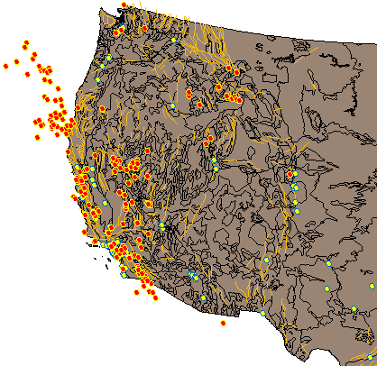
Suppose you are researching seismic activity in the Western USA. You have already put togther a map (shown in the illustration below) that shows all the earthquakes of a magnitude of 6 or more (the red circles), all the cities with a population of 100,000 or more (the yellow circles), and the major fault lines. To produce this map, you combined property and location queries to bring in the data from various sources (see Bring in a subset of features using a query).
Now you want to show which cities in the Los Angeles area are at greatest risk, based on past earthquake activity and the proximity of the cities to fault lines.
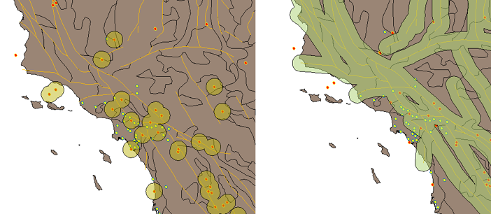
The first thing you need to do is to create a buffer layer to show the areas within a specific distance of a past earthquake, say 10 miles. You can make the buffers around the individual earthquake points overlap to form continuous zones, as shown on the left in the illustration below. Next, you do the same with the fault lines to create another buffer layer (shown on the right).
Once you have created your buffer zones, you can use a multiple-location query on the cities layer to isolate those cities that are within one or more of the buffer zones, that is, they are within 10 miles of a past epicenter or within 10 miles of a major fault line.
The first demonstration shows how to build continuous buffer zones from multiple overlapping buffers. This example creates the buffer zones for the points. However, to create buffer zones around lines, you follow exactly the same steps
Show me how to create overlapping buffer zones
The second demonstration sets up a complex query for the cities layer by selecting some of the buffer zones in the area of study. The result is a new cities layer, containing only those cities within the buffer zones.