


AutoCAD Map 3D supports grid-based surfaces such as DEM (Digital Elevation Model) files. Grid-based surfaces are raster images in which each pixel is assigned an elevation. You can theme the surface using elevation ranges, just as you theme features based on ranges of values. (If you have multiple surfaces, for example, a set of adjacent DEM files, you can bring them all into the map as a single layer, as described in Bring in data from multiple image files to a single layer.)
By default, a surface appears in the map colored in shades of green, as shown on the left below. The middle image shows the surface after it has been themed according to its elevation values.
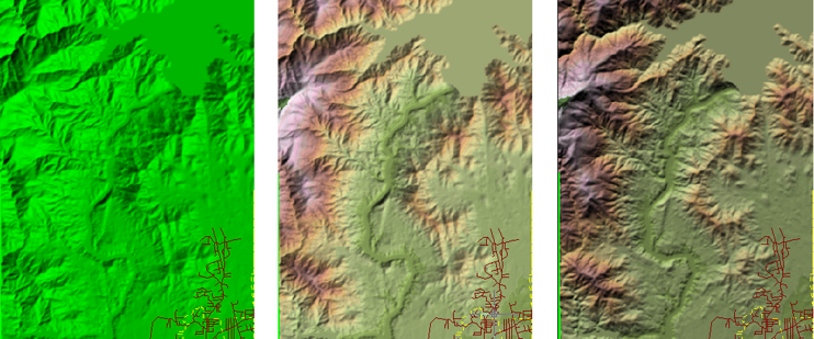
By default, the surface also has hillshading applied to it. Hillshading gives the effect that the terrain is lit by the sun, with accurate shadows and highlights for a particular time of day and latitude/longitude.
You can adjust the direction and height (angle) of the sun to give the best results for your map. For example, because the middle image is fairly even in tonality—the shades of light and dark are similar—some people will see it “in reverse,” with the mountain ridges appearing as valleys and the lake appearing to rise above its shores. This optical illusion can be eliminated by changing the sun’s angle and direction, as shown in the image on the right.
In this example, we have already brought two adjacent DEM files into our map. Now we want to color them to show the elevation of the terrain and provide a realistic background for the other layers. Because they are on the same layer, we can theme them together. This demonstration shows how to theme the surfaces using a pre-defined color palette.
Show me how to color surfaces based on elevation
The second demonstration shows how to adjust the direction and angle of the sun to give a stronger impression of light and shade. This makes the map less ambiguous and easier to read.