


In AutoCAD Map 3D, the attribute data for the features in the map is displayed in the Data Table, which is a separate window that floats on top of the work area. All features have attribute data stored in table format, even if the only attribute is a unique identification number (ID).
When you are working with parcels, they all look very similar in your map. Often it is difficult to know exactly where you are. Therefore, it is very useful to be able to quickly zoom into a particular parcel by selecting its record in the Data Table. The quickest way to select a particular parcel record is usually by typing in its ID number. Another way would be to search for all parcels on a particular street.
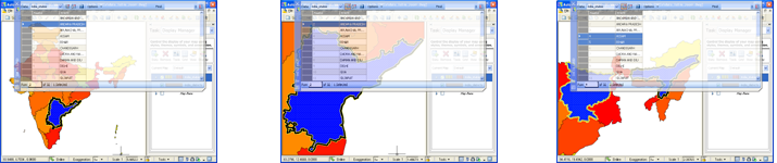
Using the Find/Search feature in this way, you select a row, or multiple rows in the Data Table. The map will zoom automatically to highlight just the selected parcel feature or features (as in the illustration in the center below). If the parcels are apart from one another, the map will zoom to show the smallest view that contains all of them (as in the illustration on the right below).
You can also do this the other way. You can select features in the map and the Data Table will scroll to highlight only the records for those features (illustration on the left below).
Notice how, in the illustration above, the Data Table is partially transparent so that you can see what is happening behind it. The first demonstration shows how to set this transparency.
Show me how to make the Data Table transparent
The second demonstration shows how to set automatic zoom so that the map zooms to the features selected in the Data Table.
Show me how automatic zoom works
The third demonstration shows how to set automatic scrolling so that the Data Table highlights only the features selected in the map.