


A DWF file is a container for a design package. As well as the print-ready sheet set, it can contain other information about the map, such as the properties for each feature. AutoCAD Map 3D can publish maps as georeferenced DWF files with coordinate information. The published maps can then be viewed in Autodesk® Design Review, which is a free viewer and editor for the DWF format.
The person viewing the DWF file can interact with the map and view the attribute data simply by selecting any of the features. Publishing a DWF file directly from a map book is a good way to share information about infrastructure with other departments or with contractors. The DWF file contains all the sheets in the map book, exactly as they were in the original DWG.
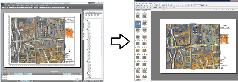
For example, the illustration below shows a tile from a map of a city street network. The view at the lower left shows how the tile appears as a page of a map book generated in AutoCAD Map 3D. The view at the lower right shows the same page as it appears in Autodesk Design Review.
Autodesk Design Review is a plug-in for the Microsoft Internet Explorer web browser. It includes a viewer for DWF files and a set of DWF editing tools. Autodesk Design Review allows you, or your field crews, to add redlining to the DWF-based map or plan, enter field notes, or make any other kind of markup. The georeferencing information in the maps allows field workers to perform two very useful tasks:
- "Interact with GPS devices to display the current location on the map.
- "Navigate automatically to a specific location by entering coordinates.
After editing, the updated DWF file can then be read back into the original DWG file for incorporation into a central data store. In this way, it is possible to “round-trip” data from the original source, to the field for as-built edits, and then back again.
For more information and download of Autodesk Design Review, see www.autodesk.com/dwf.
This demonstration shows how to specify the properties or attributes to include in the published DWF file. In this example, we use a simplified map of a city water system with waterlines, valves, and hydrants. In the publishing options, we specify that we want to include the valve type and valve number properties in the output.
Show me how to publish a map book with attributes to a DWF file