


The previous skill showed how to split a parcel that is defined as a polygon feature. However, you may also want to split parcels that are drafted as closed polylines.
For example, you might receive a design for a new subdivision already drawn as raw geometry with lines or polylines. In this case, you need to edit the parcel data, delete the old, undivided parcel feature, and replace it with the subdivided parcel geometry. In this process, you convert the raw geometry into features in the database.
The illustration below shows the division of a polygon feature on a different scale from editing a parcel, but the principle is the same.
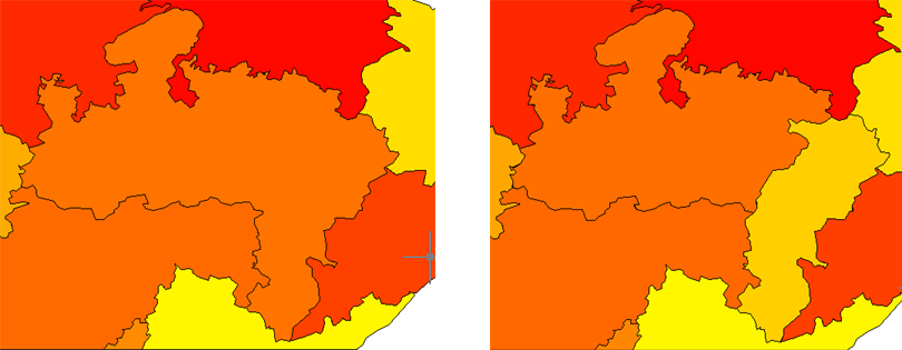
In November 2000, the Government of India created the new state of Chhattisgarh out of the eastern part of the state of Madhya Pradesh. Countless maps became out-of-date overnight. The map on the left shows the pre-2000 conditions, while the map on the right shows the state boundaries as they were redrawn in the year 2000.
In this example, the state boundaries are stored in a database (thick black lines on the map). The boundaries for the new states have been drafted as closed polylines on separate layers (thick blue and green lines). They are not visible when the animation starts. The procedure goes like this:
- Check out the old polygon feature and delete it.
- Turn on the layers with new polyline geometry.
- Create a polygon feature from the first new polyline.
- Update the attribute data in the Data Table.
- Check in the new feature.
- Repeat steps 3 to 5 to create the other new polygon and add it to the database.
Show me how to create new features from existing AutoCAD objects