


The earth is round but maps are flat. In order to display the earth on the flat surface of a map, we have to project it. A map projection, or coordinate system, is the way that a geographical area is stretched, shrunk, or otherwise distorted to make it appear flat. There are hundreds of different coordinate systems, which serve different purposes. Some are optimized for displaying small scale maps. such as maps of entire countries, while others are intended for large-scale maps of smaller areas, such as maps of a town or city. Some coordinate systems tend to preserve area at the expense of shape, and some tend to preserve shape at the expense of area, but they all make some compromises with reality. The trick is to choose the coordinate system that is best suited for the map you are going to create.
Here is a comparison of two coordinate systems, using a map of the United States as an example.
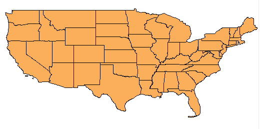
The first map (above) uses the LL84 coordinate system, which is a latitude-longitude system based on a datum (or reference point) established in 1984. You can see how the areas of the states are stretched horizontally. Distance and direction are not realistic either, as you can see from the straight line along the border with Canada at the top of the map. This coordinate system is not a good choice for a map like this one, which shows only the 48 states of the USA (not including the outlying states of Alaska and Hawaii).
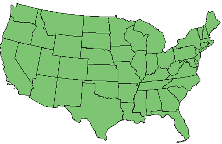
The second map (above) does a much better job of showing the 48 states with minimum distortion. The coordinate system used in this map is the Albers Equal Area (code=US48), which is specifically designed to display this kind of map of the United States. Equal-area means that one square unit in one part of the map covers the same area of the actual Earth as a square unit in any other part. So this is a more accurate representation of the area.
Sometimes you will receive data with an unknown coordinate system, or a coordinate system that is different from your current map. In these cases, you have two choices:
- If
the data has a coordinate system defined for it, but you don’t know what
it is, you can bring it into a new, empty map. In this case the
empty map will be set to the coordinate system assigned to the data.
Show me how to set a map to the coordinate system of the data
- If you know what coordinate system the data is in, but you want to change it, you can start a new, empty map and assign a coordinate system to it, or you can open an existing map in a known coordinate system. Then, when you bring in data, the data will be reprojected to the coordinate system assigned to the map.