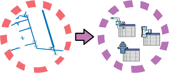
You may have read by now about the benefits of storing data as feature classes rather than DWG objects. You may already have used FDO data access technology to bring data into your map. But what if the vast majority of your data is still stored in DWG files, as raw geometry? How do you start migrating that data to a GIS data store?
Fortunately, migrating large numbers of DWG objects to SDF format is now a simple process. You can use a standard export command to get your DWG data into SDF, exporting the objects by layer. Each layer becomes a feature class in the SDF data store.
For example, if your DWG file has a layer that contains polylines representing pipes, a feature class "Pipes" is created in the SDF file and each line on that layer becomes a pipe feature. The same transformation happens for any other layers that you select, for example, the hydrants and valves in the illustration below. If your DWG has object data defined for the objects, the object data is copied to the SDF file and stored as properties of the features.

If the final destination of your data is Oracle, you can use the Export to Oracle command in AutoCAD Map 3D to copy the data directly into the database. All you need to do is make a connection to the Oracle database. If the final destination is some other data store, for example Microsoft® SQL Server™, you can export to SDF and then use bulk copy to transfer the data from SDF format to the SQL Server database (see Bulk copy data from a SHP file to an SDF file).
The first demonstration starts with a DWG file with many layers. We want to export the objects on three of the layers, convert those objects to features, and then store the features in SDF format. We also want to make sure that the object data associated with the objects is exported at the same time.
Show me how to export DWG objects to SDF
You can also go the other way, that is, import features from an SDF file and convert them into DWG objects. This process is useful if you keep your data in DWG files but need to receive data from engineers or contractors who are using SDF or some other FDO-based data store.
Importing features is different from simply connecting to an SDF data source and adding feature classes to the map. In the latter case, the features are displayed in the map but the original data stays in the SDF file. (The DWG stays more or less the same size.) When you import, the data is copied from the SDF file and objects are created in the DWG. (The DWG gets bigger.)


