


You can use the AutoCAD Trim and Break commands to split polygons. However, the Split command has many advantages over those methods. A split always results in a valid feature, and has special logic to deal with attributes automatically.
With Split, you can set rules for the assignment of properties when you split and merge geospatial features. You can use expressions for these rules.
For example, if you are splitting a parcel, you can specify that the land value of the resulting parcels be based on a calculation that you define. There are also choices for automatic calculations, such as assigning the average value of all merged features to the resulting feature, or dividing the value of a feature evenly among all its split features.
- To display the Data Table, in Display Manager, select the Parcels layer and click Table in the Task Pane.
- In
the Data Table, click Options (at
the bottom of the window) and select Set Split And Merge
Rules.
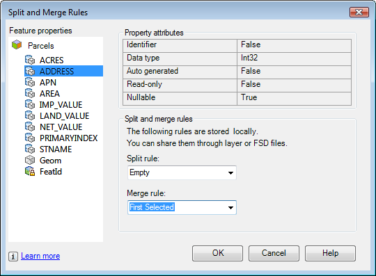
Each property of the Parcels feature is listed under Feature Properties on the left. Two properties (Geom and FeatID) are generated by the data store, so you cannot set rules for them. If you select them, you can see the rules that the data store uses to create them.
- In the Split And Merge Rules dialog box, click the ADDRESS property.
- For
the Split Rule, specify Empty.
If you split this parcel, you must specify the address number for each new parcel that is created.
- For
the Merge Rule, specify First
Selected.
If you merge multiple parcels into one, the new parcel will use the address number of the first parcel you select for the merge.
- Specify
rules for other properties, using the table below as a guide.
Property Split rule Merge rule ACRES Proportional Based On Area2D (Geom) Sum APN Copy First Selected AREA Proportional Based On Area2D (Geom) Sum IMP_VALUE Proportional Based On Area2D (Geom) Sum LAND_VALUE Proportional Based On Area2D (Geom) Sum NET_VALUE Proportional Based On Area2D (Geom) Sum PRIMARY_INDEX Empty First Selected STNAME Copy First Selected For a complete description of the split/merge rule options, see
Using Expressions In Split/Merge Rules. - Click OK.
To continue this tutorial, go to Exercise 2: Find the parcel to split.