(What is MOd3D?)
From Mod3D
What is Mod3D?
Mod3D is an interactive 3D geophysical gravity and magnetic modeling software.
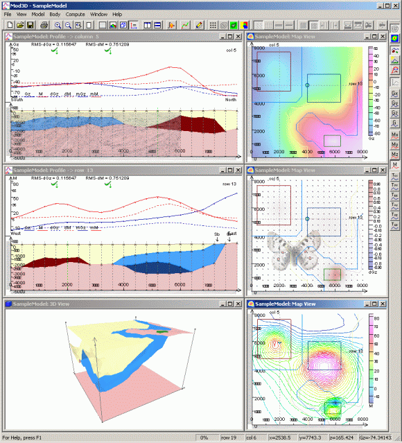
Mod3D has been developed to create 3D geophysical models in an user friendly interactive environment. Anomalous gravity and/or magnetic fields are computed using formulae for polyhedral bodies. The Map View, Profile View and 3D View are provided on modeled half-space. The Map View provides an overview on the model geometry projected to the horizontal plane, and shows bitmaps or contours of modeled field grids and topography. The Profile View provides an interface, where the polyhedral bodies are defined in sets of perpendicular cross sections running through the grid nodes. More profiles can be opened simultaneously, to get better overview over the geometry in both south-north and west-east directions respectively. Copying of the bodies or the whole cross section to the next or previous profile followed up by reshaping of the geometry speeds up the process of model creation. Profile view also shows curves of computed and/or measured and/or difference fields. Geo-referenced bitmaps could be imported into Mod3D, and drawn transparently to the Map View or Profile View. An example would be a geological map shown in Map View, or a seismic section displayed in a selected Profile View. Main geological units could be digitized in Map View which are shown as check marks to achieve better orientation in the Profile View. The model definition system controls internally the consistency of the polyhedra geometries, or their topology in other words. The controlling system prevents overlapping or crossing of the polyhedra, simplifies reshaping of the existing bodies and reduces time needed for model creation.