MapCruncher for Microsoft Virtual Earth Help
From MapCruncher
MapCruncher Limitations
This topic describes some known limitations of MapCruncher.
Schematic (not to-scale) Maps
MapCruncher is not designed to handle schematic (not to-scale) maps. In a to-scale map, MapCruncher can infer from only a few correspondences how all of the rest of the data should be transformed. In a schematic map, the cartographer has taken arbitrary liberty with the world geometry, and no set of correspondences say anything certain about other unlabeled points.
Approximate Re-Projection
MapCruncher uses an approximation to re-project to-scale maps from their original projections into Virtual Earth’s Mercator projection, and thus sacrifices some precision in feature location. Disciplined cartography involves understanding both the relationship between angular measures (latitude and longitude) and the surface of the Earth, and the relationship between those angular measures and the surface of the map (projection geometry). MapCruncher understands neither. Instead of modeling source projection, source datum, Virtual Earth datum, and Virtual Earth projection, MapCruncher uses a simple function to directly approximate the relationship between the original map and the Virtual Earth map.
Mathematically speaking, MapCruncher uses either an affine or a quadratic polynomial to approximate the projection. The quadratic polynomial admits curvature in the approximation, which helps handle the curves that appear in conic projections, as shown in Figure 1.
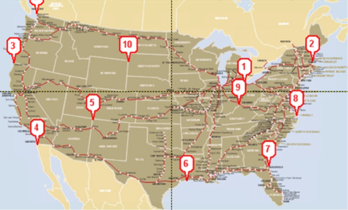
Figure 1. Approximate projection
Polynomial fitting can only be approximate, because a polynomial can never quite match the trigonometric curves produced by geographic projections.
However, that the approximation is suitable for a wide variety of maps. Frequently, the source map exhibits more internal error than the approximation. Approximation error is apparent in very detailed maps (maps whose smallest feature is tiny compared to the extent of the map): In the case of the King County Bike Map, the approximation seems to be responsible for errors of up to about a quarter-block.
Some High Zoom Levels Cause Long UI Stalls
If you zoom far into a vector map with text, the UI can stall (including a frozen mouse pointer) for quite some time. The only work-around is to avoid zooming too far into a vector map with text.
Browser Support
MapCruncher is compatible with the following browsers:
- Microsoft Internet Explorer 6 and later versions on Microsoft Windows
- Mozilla Firefox 1.5 and later versions on Microsoft Windows, Apple MacOS X, and Linux
| © 2007 Microsoft Corporation. All rights Reserved. | Send Documentation Feedback |