Best Matching Unit to Shapefile
From SOM Analyst
Best Matching Unit to Shapefile
Creates a shapefile from projected data.
ArcGIS Reference
Parameters
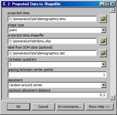
- projected data
- The input projected data file.
- shape type
- The type of shapes to use to represent the data.
- projected data shapefile
- The output shapefile to contain the projected data shapes.
- label from SOM data
- The unprojected SOM data file that contains the values and labels to use for the projected data.
- Cartesian quadrant
- The Cartesian quadrant in which to place the shapes.
- spacing between center points
- The spacing between the units in the SOM on which the projected data will be displayed.
- placement
- The placement location on each SOM unit to use for the projected data shapes.
- maximum placement distance
- The maximum distance from the center of the SOM units to place the projected data shapes.
Code Reference
- uiBMUtoSHP.BMUtoSHP(bmufile, outfile, labels, quadrant, spacing, placement, distance)
Creates a shapefile from a BMU file.
Arguments : - bmufile
The input BMU filename.
- outfile
The ouput shapefile name.
- labels optional
A data file that contains the labels for the column values.
- quadrant optional
The Cartesian quadrant to use.
- spacing optional
The spacing between units in the SOM.
- placement optional
The method for placement within a neuron.
- distance optional
The maximum distance for the placement.