


Once you have defined a network topology in your map, you can use it to perform different types of analyses:
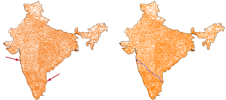
- Shortest
path—Find the shortest distance between any two points in the network.
Typical applications: dispatching emergency vehicles, getting driving
directions. The illustration shows the shortest distance by road from
the city of Mumbai, on the West coast of India, to Chennai, on the East
coast.
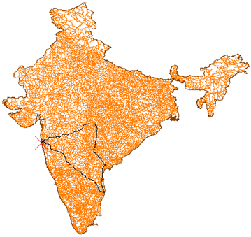
- Best route—Find the optimal route from a start
point to one or more intermediate points and back to the start point.
Typical applications: optimizing truck delivery rounds, planning
public transport. The illustration shows the route from Mumbai to
Chennai and back, passing through three other cities on the way.
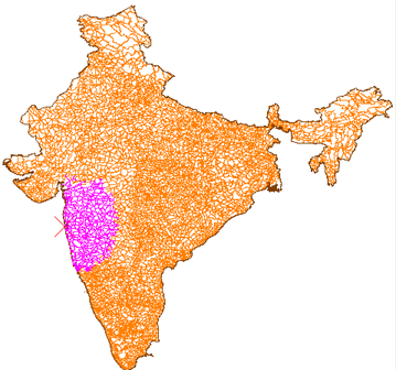
- Flood trace—Find all the possible routes from a given point. Typical applications: determining the reach of a water pump, finding the effective coverage of a customer-service center. The illustration shows all the road segments within 500 kilometers of Mumbai.
In most cases, when you perform these kinds of analyses, you will want to take into account the resistance to travel along certain line segments, such as road speed limits, as well as physical limitations, such as pipe width. For example, the shortest distance by road between two cities may not always have the fastest journey time. There may be a freeway, which takes a longer route, but which has a much higher speed limit. (These are the kind of calculations that are made when you get driving directions from a web-based mapping service.) Another example would be the resistance to crossing a particular point, such as a valve in a water network. In AutoCAD Map 3D, you can specify link resistance and node resistance across your entire network using expressions and object-data tables.
When you open a map that has a topology defined in it, the topology is not loaded. Before you can use it, you must load it. This step also audits the topology to make sure that it is correct and complete.
Show me how to load a topology
There is a lot of functionality that you can use when performing a network analysis, particularly to help you specify resistance factors. However, the following demonstration keeps things simple and shows how to find the shortest path between two points in the network, without calculating any resistance. The other kinds of analysis: Best Route and Flood Trace are very similar. (If you want to learn more about the different kinds of network analysis, there is a detailed description in the AutoCAD Map 3D Help.)